


D38 - GR 10

loic09
Gebruiker

Lengte
24 km

Max. hoogte
2015 m

Positief hoogteverschil
739 m
Km-Effort
35 km

Min. hoogte
1477 m

Negatief hoogteverschil
944 m
Boucle
Neen
Datum van aanmaak :
2014-12-10 00:00:00.0
Laatste wijziging :
2014-12-10 00:00:00.0
7h13
Moeilijkheid : Medium

Gratisgps-wandelapplicatie
 SityTrail
IGN / Geografische instituten
SityTrail Plus
De wereld gaat voor u open
Over ons
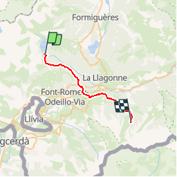
Tocht Stappen van 24 km beschikbaar op Occitanië, Pyrénées-Orientales, Les Angles. Deze tocht wordt voorgesteld door loic09.
Beschrijving
Barrage des Bouillousses/Refuge de l'Orry

Plaatsbepaling
Land:
France
Regio :
Occitanië
Departement/Provincie :
Pyrénées-Orientales
Gemeente :
Les Angles
Locatie:
Unknown
Vertrek:(Dec)
Vertrek:(UTM)
418237 ; 4712373 (31T) N.
Opmerkingen